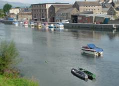
Carrick On Suir                        

Access to Carrick On Suir is restricted to 2.5 hours before and after high water for Carrick.  The final 0.5 km of channel into Carrick On Suir is mainly close to the south bank, as there are many shoals and one particular group of rocks.  Close to and within view of the town, there is an island, which is left to starboard by staying again close to the south bank.  On the port side there is a private pontoon. Continuing into Carrick, pass under Dillon Bridge and before the second Old Bridge on the North Quay, is the marina with visitor berths available.


Carrick On Suir

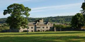
Carrick on Suir is set in the Golden Vale with the Comeragh Mountains to the south and Slievenamon to the north.  From the 14th century, Carrick was the Ormond’s stronghold and it was the 10th Earl Thomas Butler, who built the Elizabethan manor house onto the 15th century castle, creatingIreland’s only Tudor manor. The Carrick Bend knot is so called because the knot is exhibited so many times therein.  There is also a clock tower from 1783, St. Molleran’s Church (1336), Ahenny & Kilkieran Celtic crosses.and several public parks.

The 13th Century bridge was the first river crossing on the Suir, built using lime, sand, cow’s blood and horse hair and by the same order of monks, who built Hook Lighthouse.  Carrick On Suir was Ireland’s furthest inland working port.

The town has a hotel, guesthouses, caravan and camping park, pubs, bank, shops, Sean Kelly Sports Centre, swimming pool, horse riding, golf course, tennis courts and a tourist office, based at the Heritage Centre.

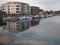
Carrick On Suir Marina offers secure access with shore facilities for visiting boats.  For access to the marina, contact Jim Power at Mob: +353 (0)87 6934447


Contacts

>Carrick On Suir Marina (Jim Power): Mob: +353 (0)87 6934447

·      >River Rescue: + 353 (0)86 8179531

>Gardai (Police): +353 (0)51 642040

>Doctor: +353 (0)51 640542

>Tourist Office+353 (0)51 640200 www.carrickonsuir.ie

Section30b: Section Chart