|
After
passing under Ferrymountgarrett Bridge
and Ringwood House on the north bank,
the
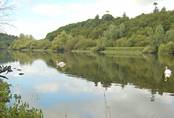
River Nore joins the River Barrow on the starboard side. Coming
downriver, the junction is sometimes passed before it is noticed. The
River
Nore is navigable 8 miles to Inistioge, where the quay dries out at
low tide and flat-bottomed boats can sit or alternatively there is a
pool opposite, where boats can remain afloat. It is not possible to
navigate the final 3km / 2 miles for 2 hours either side of high
water: and there are obstacles downstream as the tide falls. Stay
mid channel going upstream.
Rathsnagadan
After
turning up into the Nore, you pass farmland and woodland until
Ballyneale, where the remains of a coal depot survive on the west
bank. An ancient church set in the valley of Glensensaw or St. Xavier
was connected to Duiske and a monastery in Rosbercon. Along this
stretch, otters are frequently spotted.
 On
the east bank, Russellstown House is visible above the treeline and a
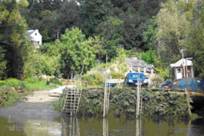
large lime kiln sits on the bank. Further up river, Rathsnagadan or
Ballingoth provides a pretty view with holiday cottages, a slipway,
quayside and many moored cots and boats. At the top and bottom of the
tide, the slipway is a hive of activity with 24 licenced cots working
out of this spot and they can be seen working in pairs from the Red
House down to Ballyneale.
Dysartmore Estate stands on the opposite side of the river. On
the east bank, Russellstown House is visible above the treeline and a
large lime kiln sits on the bank. Further up river, Rathsnagadan or
Ballingoth provides a pretty view with holiday cottages, a slipway,
quayside and many moored cots and boats. At the top and bottom of the
tide, the slipway is a hive of activity with 24 licenced cots working
out of this spot and they can be seen working in pairs from the Red
House down to Ballyneale.
Dysartmore Estate stands on the opposite side of the river.
Clodiagh
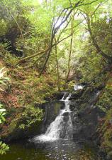
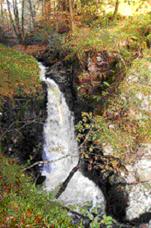 Up
river from here, Clodiagh River runs along a rocky riverbed and
plummets 18m before flowing into the Nore. The waterfall is described
as follows:
In a
romantic creek up the Nore is Clodagh waterfall; it is a cascade of
great beauty falling down a rugged precipice of about 60 feet. -A
Topographical Dictionary of Ireland (1837).
The
notorious robber Freaney is reputed to have stashed his loot at the
bottom of the waterfall. Up
river from here, Clodiagh River runs along a rocky riverbed and
plummets 18m before flowing into the Nore. The waterfall is described
as follows:
In a
romantic creek up the Nore is Clodagh waterfall; it is a cascade of
great beauty falling down a rugged precipice of about 60 feet. -A
Topographical Dictionary of Ireland (1837).
The
notorious robber Freaney is reputed to have stashed his loot at the
bottom of the waterfall.
St
Brendan’s church upstream
at
Clodiagh
Bridge,
dates from 1700; and is so well hidden that it was bypassed by English
forces when they were trying to destroy all of the Roman Catholic
churches in Ireland in 1798. The waterfall is accessible via
Coolnamuck Quay or by road, via a wooded track although the final
approach is through dense woodland and down a steep bank.
Brownsford Mines
 The
river then turns into a steep-sided horseshoe bend before arriving at
Brownsford Quay. These quays are traditional access
points for local fishing cots and are not adequate berths for
cruisers. At this access point, the track turns away from the river
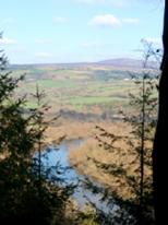
and zigzags its way up the steep bank until it turns left onto a
woodland track. This woodland track provides dramatic views down onto
the river, up the Nore Valley and across to Brandon Hill. There are
large specimen trees along the route including some unconventional
plantation trees such as eucalyptus.
As the
trail starts to descend, it approaches two small chasms in a rock
outcrop and the old mines: It is not advised to proceed any further. The
river then turns into a steep-sided horseshoe bend before arriving at
Brownsford Quay. These quays are traditional access
points for local fishing cots and are not adequate berths for
cruisers. At this access point, the track turns away from the river
and zigzags its way up the steep bank until it turns left onto a
woodland track. This woodland track provides dramatic views down onto
the river, up the Nore Valley and across to Brandon Hill. There are
large specimen trees along the route including some unconventional
plantation trees such as eucalyptus.
As the
trail starts to descend, it approaches two small chasms in a rock
outcrop and the old mines: It is not advised to proceed any further.
Brownsford Castle
 Above
the bank, stands
Brownsford Castle,
for many centuries a
FitzGerald stronghold.
The castle was
acquired in 1867 by a landlord (Garvey),
who set about evicting his tenants. “There
were people who had built their own stone cabins with their bare hands
in Brownsford, which was in itself a village with a row of houses…The
landlord, the police, under the charge of the Resident Magistrate..and
the crow-bar brigade (from Thomastown) arrived and.. the work of
demolition continued until twenty families had been left with only the
bare walls of their homes standing.. the cries and screams that rent
the air are more easily imagined than described…. taking shelter
wherever they could, more frequently than not within those bare walls,
their lives wrecked.”
Garvey
built the walls around his castle from the stones of the cabins he had
destroyed. Many families walked away and up the hill to cross over to
New Ross to board the emigration vessel to Quebec. Above
the bank, stands
Brownsford Castle,
for many centuries a
FitzGerald stronghold.
The castle was
acquired in 1867 by a landlord (Garvey),
who set about evicting his tenants. “There
were people who had built their own stone cabins with their bare hands
in Brownsford, which was in itself a village with a row of houses…The
landlord, the police, under the charge of the Resident Magistrate..and
the crow-bar brigade (from Thomastown) arrived and.. the work of
demolition continued until twenty families had been left with only the
bare walls of their homes standing.. the cries and screams that rent
the air are more easily imagined than described…. taking shelter
wherever they could, more frequently than not within those bare walls,
their lives wrecked.”
Garvey
built the walls around his castle from the stones of the cabins he had
destroyed. Many families walked away and up the hill to cross over to
New Ross to board the emigration vessel to Quebec.
Continuing
on up the river,
waterfalls cascade down the east banks into the river. Woodland gives
way to pastureland and
Clonamery Church, where
St
Bronndan founded a monastery, which was in use until Edward Fitzgerald
fell at the Battle of Aughrim in 1691. Mass was then said on a rock
at the foot of Brandon until Clodiagh
church was built. Inistioge
Church displays a stone carving from Clonamery, depicting a mermaid,
said to be found in other Churches of St Brendan.
The Red House
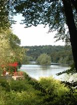 The
Red House is a landmark for boat users on the west bank, marking
the limit of the navigation, except for high tide. It was once a
water inn and then a restaurant. It is possible to anchor here at all
states of the tide but down river from here can get tricky at low
tide. The
Red House is a landmark for boat users on the west bank, marking
the limit of the navigation, except for high tide. It was once a
water inn and then a restaurant. It is possible to anchor here at all
states of the tide but down river from here can get tricky at low
tide.
On
the riverbank and adjacent to
the
house, the track crosses a small bridge and leads up a steep bank, at
the top of which stands the ruins of the
swiss
cottage,
a component of Lady Tighe’s original river walk. The river walk
continues past the swiss cottage following Brownsford Stream up
river. Halfway up the path to the cottage a bridge has been
constructed across the stream to afford a view of a waterfall and of
the stream running down to the original stone bridge.
|
