|
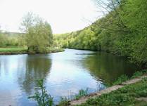
From the Red House, navigate close to the east bank and then
north bank, keeping the islands to port all the way to Inistioge.
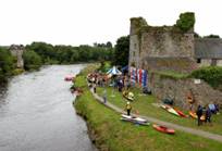
Inistioge Quay
 The
old quay at Inistioge is the limit of the navigation and
dries
out at low tide.
There
are rocks and shallows in the river upstream from the quay.
Flat-bottomed boats can sit at the quay wall or alternatively there is
a pool opposite, where boats can remain afloat. The slipway adjacent
to the quay is very popular with swimmers. A road leads from the
quay, across the bridge and into the village.
Inistioge is a beautiful village and there are restaurants, cafes,
pubs and a shop. The
old quay at Inistioge is the limit of the navigation and
dries
out at low tide.
There
are rocks and shallows in the river upstream from the quay.
Flat-bottomed boats can sit at the quay wall or alternatively there is
a pool opposite, where boats can remain afloat. The slipway adjacent
to the quay is very popular with swimmers. A road leads from the
quay, across the bridge and into the village.
Inistioge is a beautiful village and there are restaurants, cafes,
pubs and a shop.
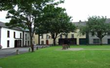
Inistioge Village
 Inistioge was the
location of an early Christian monastic community founded by Saint
Columcille. The earliest recorded mention of Inistioge is in the C16th
Annals of the Four Masters, referring to a battle between the
kingdom of Osraighi and an army of Norsemen in the year 962 AD. Inistioge was the
location of an early Christian monastic community founded by Saint
Columcille. The earliest recorded mention of Inistioge is in the C16th
Annals of the Four Masters, referring to a battle between the
kingdom of Osraighi and an army of Norsemen in the year 962 AD.
The Augustinian
Priory founded in 1210 by Sir Thomas FitzAnthony Walsh, is now in
ruins and its ivy-clad tower is commonly known as the Black Castle.
The church of St. Mary, a 16th century structure
incorporates the medieval nave and Lady Chapel of the older structure,
and has its own White Tower. Interesting features include monuments
to the Tighe family. Fragments from the mediaeval cloister are
incorporated into the perimeter walls of the parish church of St
Columcille (RC), erected in 1836.
The
castellated edifice on the west side of the village square was
originally a C14th merchant’s house. The obelisk
commemorates David Fitzgerald, Baron of Brownsford (d.1621). Sarah
Fownes Tighe built an almshouse for local widows in 1780, and William Tighe’s s widow erected the fountain in his memory in 1879.

Nore Trail
 There
is also an option in the village park, to turn up river and follow the
Nore Trail to Thomastown. The path follows the riverbank and
boardwalks, bridges and stiles are provided as needed. The Nore Valley
trail will eventually lead from Kilkenny to New Ross. There
is also an option in the village park, to turn up river and follow the
Nore Trail to Thomastown. The path follows the riverbank and
boardwalks, bridges and stiles are provided as needed. The Nore Valley
trail will eventually lead from Kilkenny to New Ross.
Rock Road Walk
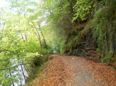 On
entering the village square, turn left to come back down the west bank
on the rock road, which is part of the South Leinster Way.
Approximately 100m along this road, there is an option to take a
pathway to the right up the hill to
Mount Sandford Castle and then on to Woodstock Estate.
Following the rock road
and
ignoring the Woodstock option; the trail passes the island, canal and
slipway
on the opposite bank.
The trail is bordered by a steep rock
outcrop and woodland. On
entering the village square, turn left to come back down the west bank
on the rock road, which is part of the South Leinster Way.
Approximately 100m along this road, there is an option to take a
pathway to the right up the hill to
Mount Sandford Castle and then on to Woodstock Estate.
Following the rock road
and
ignoring the Woodstock option; the trail passes the island, canal and
slipway
on the opposite bank.
The trail is bordered by a steep rock
outcrop and woodland.
 Along the route, a short pathway
diverts to an old cold store above the main
trail. As the trail follows the river southwards, it passes
the islands and eventually comes back to the Red House and the
waterfall. Along the route, a short pathway
diverts to an old cold store above the main
trail. As the trail follows the river southwards, it passes
the islands and eventually comes back to the Red House and the
waterfall.
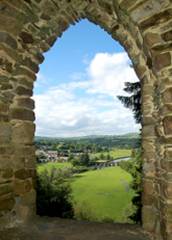
Mount Sandford Castle
The
path to Mount Sandford Castle ascends steeply but the castle
offers spectacular
views over Inistioge, the island, canal and the
River Nore valley.
The
folly was
erected in 1769. Turning right, up the hill, the trail joins the main
driveway into Woodstock Estate.
|
